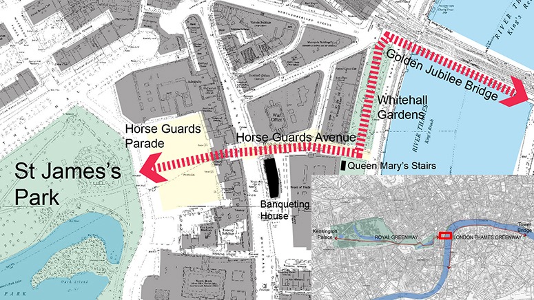
London has two excellent greenways: one of them was planned by Henry VIII and runs through the Royal Parks. The other was planned by a landscape architect (Sir Patrick Abercrombie) and runs on the South Bank of the River Thames from Westminster Bridge to Tower Bridge. The video explains the histories of the routes and how the Lost Garden of Whitehall Palace could and should be a link between the two greenways.
London’s geography is confusing for the pedestrian and the cyclist. A 6-mile London Greenway, running from Kensington Palace to Tower Bridge would create a great east-west spatial corridor, ‘green’ in the sense of environmentally wonderful and a ‘way’ in the sense of a traffic-free pedestrian concourse passing near many of London’s best tourist attractions: the Tower of London, the Globe Theatre, Tate Britain, St Paul’s Cathedral, the London Eye, Westminster Abbey, the Houses of Parliament, the Lost Garden of Whitehall Palace, St James’s Park, Buckingham Palace, Hyde Park, Kensington Palace and Gardens.
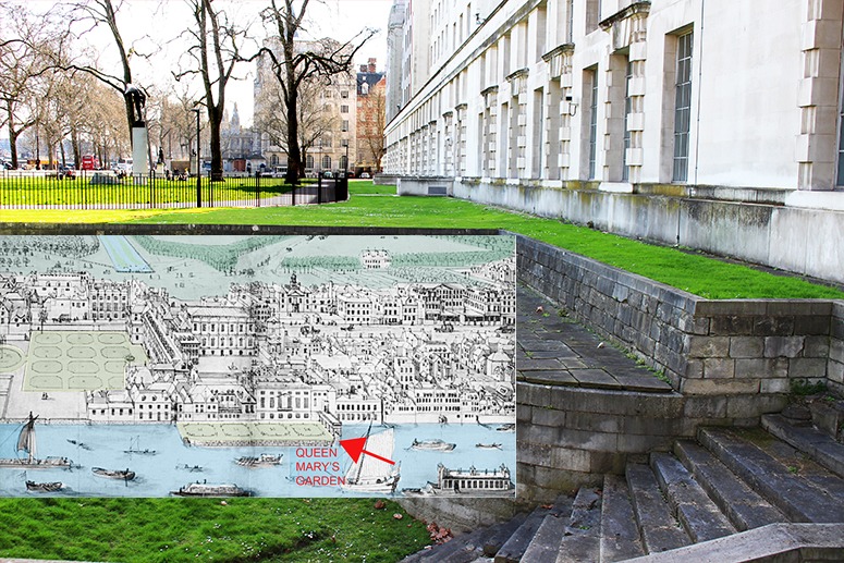
The Ministry of Defense (the building on the right in the photograph below) occupies the site of the main buildings of Henry VIII’s Whitehall Palace. The architect preserved a fragment of Queen Mary’s Stairs and the Ministry kindly allow public access to what was Queen Mary’s Garden. We could admire them even more if the parterre’s shown on Knyff’s drawing of the garden were to be restored. Sadly but understandably, the Ministry keeps Henry VIII’s Whitehall Palace Wine Cellar for private use.


Yes to reconstructing Queen Mary’s Garden in the 21st century. Is the public space occupancy shown in the video typical of 1) a weekday, 2) weekend, 3) public holiday, 4) annual holiday or 5) tourism season?
Usage is obviously higher at weekends and in good weather but even on cold winter mornings there is a fair amount of traffic on these routes with the usual mix of commuters and tourists. There must be some local residents but I doubt I would guess they come third in terms of numbers. London tourism continues round the year http://www.smartertravel.com/travel-guides/page.php?id=1300831 with some peaks and some troughs. My impression is that, as everywhere, tourist numbers are sharply higher than 30 years ago. There are of course many quiet areas in the parks but the busy sections of the river route can get very congested.
If tourists are the largest group and locals are the third largest group are commuters the second largest group in crowds?
It is interesting that new dwellings get built for higher populations and new roads for higher traffic volumes, but perhaps increases in public visitation doesn’t attract the same attention? If so, public spaces are more likely to get congested without anyone feeling a responsibility to plan for the increase in usage.
If the tourism numbers increase sharply this is likely to impact on local amenity values – ie the livability (not to mention the sustainability) of the city.
Perhaps cities should do surveys of key urban sites to consider the dynamics of urban usage patterns?
The Rocks central Sydney [ http://www.owenwilson.com.au/system/files/imagecache/product_full/SYD0198%20%20Australia%20Day%20Street%20Party%20George%20Street%20Sydney%20%20SYD0076.jpg ] and Covent Garden London [ http://cdn.londonandpartners.com/visit/london-organisations/covent-garden/63912-640×360-covent-garden-640.jpg ] and Times Square at 2am [ http://intelligenttravel.nationalgeographic.com/wp-content/blogs.dir/10/files/2012/11/times-square-new-york-city.jpg ].
To some extent, I think of the old story of the man who stood on a street corner staring at the top corner of a building and making an occasional gesture. Before long, a small crowd had gathered – with each addition wondering what the others were staring at. There are lots of good things to see along London’s central east-west greenway but I also believe that tourists attract tourists. There is an excitement in crowds. Some places get more tourists than they deserve and others have fewer. This makes it hard to plan for tourist numbers. My impression is that the public spaces for the Queen Elizabeth Olympic Park were too big for the games, except perhaps on a few days, and are now far too big for park use – unless they make it Europe’s premier tourist destination.
For how many days/year is Sydney’s George Street given over to pedestrian use? England has had a ‘Keep Sunday Special‘ campaign for some years. It has a Christian origin but has sensibly extended to other objectives.
Yes there is something in the phenomenon of crowds. It is one of the interesting aspects of design we explored as interior designers – but it is even more relevant to urban design questions.
It is interesting to experience ‘tourism’ in a number of ways to realize that some places have an ‘accidental’ character and others are more ‘made’. I am sure there is an international tourism map of London depending on your length of stay (ie 5 days, 2 weeks and 3 months etc), as well as a national tourism map of London (ie the places you take out of town visitors) and a local map (ie all the cafes, bars, shops, theatres and other destinations known and frequented mostly by the locals).
Queen Elizabeth Olympic Park would have a pedigree similar to Southbank Parklands in Brisbane [ http://www.worldofwanderlust.com/wp-content/uploads/2013/09/southbank.jpg ] that started its life as the venue for Expo 88. [ http://www.abc.net.au/reslib/201304/r1107902_13436013.jpg ]
I am not entirely convinced of the ‘pedestrianisation’ of George Street. [ http://www.smh.com.au/nsw/driven-out-how-much-of-george-street-should-be-closed-to-cars-20130404-2h8j9.html ]
My reasoning is that Sydney has a plethora of public spaces, but the civic amenity of many of these spaces is poor. [ http://images.smh.com.au/2012/01/10/2883867/Sydney-Town-Hall729-420×0.jpg ] It is gradually improving the urban amenity of the area around the Town Hall and has a way to go to make Martin Place anything other than a convenient area to traverse quickly from George to Macquarie Street. The lower end of George Street from Central Station going towards Sydney University is gradually improving also (only due to the consolidation of the university precinct).
There is incredible potential – but it seems not much vision – for what already exists!
Southbank Parklands look like a terrific success and I will be delighted if the Olympic Park turns out this way.
Re pedestrianisation, two European examples come to mind. In Copenhagen, they just went for it and pedestrianised the Strøget. It was a great commercial success but not too much of a visual success [though it could hardly have been done in a significantly different way]. In London, whisper it, Oxford Street is on course to pedestrianised. The pavements have been getting wider decade by decade and if you plot this on a graph the street will be car-free by 2050. Since shopping in Oxford Street remains a nasty experience I think this will turn out to be the right solution. But the people would not accept it in one bite and those who manage George Street might consider a more softly-softly approach. Finding what is ‘right’ depends on many local factors and anyone who offers a panacea is mistaken.
It is worth exploring the visual character of the Stroget [ http://www.copenhagenet.dk/cph-map/Images/Ped-skygge.jpg ] and [ http://blogs.cornell.edu/cualnl9hrz5/files/2012/09/Stroget_Avenue-10u9oac.jpg ] as well as its mapping qualities [ http://fc08.deviantart.net/fs71/i/2013/153/0/4/sketch_map_of_stroget_by_meanor-d67jiit.jpg ] and history of its development [ http://www.everyculture.com/images/ctc_02_img0315.jpg ] to understand its uniqueness as well as its universal qualities.
It seems to have had a history as a pedestrianized space [ https://www.pps.org/graphics/upo-pages/stroget1968_large.jpg ] which perhaps became retrofitted to accommodate cars? [ http://bikedenton.files.wordpress.com/2010/08/strc3b8get-before.jpg ]
My memory, from a few years back, is of it being predominantly like your first image http://www.copenhagenet.dk/cph-map/Images/Ped-skygge.jpg ie cold and gloomy with dull paving (and few other options, because of the restricted width). It looks fine on the other two pics and on the old pics. My suggestion are (1) re-pave the dull sections with a richer and more colourful materials (2) incorporate lighting built into the paving (3) find a way of incorporating flowers (maybe fixed to buildings or cables (4) consider retractable overhead canopies for use in bad weather.
It is interesting that Ottawa is looking to Copenhagen to revitalize its street life.[ http://www.canada.com/ottawacitizen/news/story.html?id=d47ee45e-4f47-4b2b-b947-ab95578e2e8a ]
The temperatures in Copenhagen’s winter are relatively mild. [ http://www.bbc.com/weather/2618425 ] While in Ottawa they are more extreme. [ http://www.ottawacitizen.com/Ottawa+coldest+winter+years+Here+season+felt+very+long/9574152/story.html ]
It would be interesting to understand the seasonal use of the outdoor public spaces. Also the difference between destination spaces and transit spaces (a concept familiar to shopping malls) would be worth greater exploration.
The laneways of Melbourne look different in winter [ http://bestjobs.australia.com/Images/State/vic/socialfeed/Melbourne-laneways~lge.jpg ] than they do in summer. [ http://static.businessinsider.com/image/5140e6c16bb3f7752b000007/image.jpg ]
Different at day [ http://ramp1885.com/wp-content/uploads/2011/12/melb-laneways.jpg ] than they do at night. [ http://emmasalkild.files.wordpress.com/2011/09/mel1.jpg ]. Different for events
[ http://www.vmec.com.au/media/images/backgrounds/laneway.jpg ] and [ http://blog.thatsmelbourne.com.au/files/2012/07/Flowers-in-the-laneway.jpg ] than they are day to day. [ http://www.wego.com.au/travel-guide/wp-content/uploads/2013/11/melbourne-laneways.jpg ]
Though often aware of the distinction between destination and transit spaces I had not put names to them and am grateful for the distinction. But I wonder what it takes to convert a transit space into a destination space. Size is not enough. I guess it needs fountains, fast food, sitting places, shops, statues etc.
Interesting pics of Melbourne thank you. If shown the pics without any lettering I would have guessed they were taken in one of Europe’s ‘Latin’ countries.
Re season and weather, I think streets are less affected than squares and that their affect on squares depends on their typology. My guess is that, in London, Trafalgar Square, for example, is less affected than Soho Square.
Yes, it seems Soho Square is particularly popular at lunch hour in the summer for office workers (and perhaps not so popular on weekends). [ http://www.gardenvisit.com/assets/madge/soho_square_garden1/original/soho_square_garden1_original.jpg ] and [ http://static.flickr.com/103/287868627_b932b54401_o.jpg ] I am not sure that it is sleazy as you say but rather that the office workers are keen to loose that pasty winter look as soon as they can.
Trafalgar Square is most probably busier during the spring and summer and the prime tourist season. [ http://architecture.org.nz/wp-content/uploads/2011/06/trafalgar_square.jpg ] If they can spare the space my vote is to make the maze permanent! [ http://4.bp.blogspot.com/_bkcCrAU0pU8/TFdBCmn0Q-I/AAAAAAAAAqQ/O6nawnJCHnI/s1600/Trafalgar+Square_Maze_01%5B3%5D.jpg ] and
[ http://www.globeimages.net/data/media/210/trafalgar_square_in_london.jpg ]
You are right Soho Square and Trafalgar Square are probably both transit (because of the destination buildings around their edges) and destination spaces (because of the activities that occur within them), but to differing degrees.
Beyond the functional aspects it is necessary to look at what makes them good spaces to be in and good spaces to pass through.