Category Archives: SUDS urban water

Is Turenscape's Qiaoyuan Park in Tianjin a model for Chinese landscape architecture? 请看一看土人景观事务所的作品-天津桥园公园


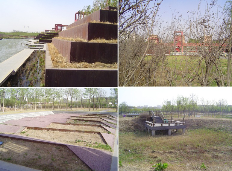
Please have a look at Turenscape’s photographs of Tianjin Qiaoyuan Park – you can see why the American Society of Landscape Architects (ASLA) gave Tianjin Qiaoyuan Park an award.  Then please consider the above photographs. They were taken on a crisp Sunday in April: the park is bare, dry and without people. Did the ASLA act in haste? Did the ASLA judges visit Tianjin? Are the ASLA judges regretting their decision? If the design was as good as it looks on the designers’ photographs, shouldn’t it be full of people on a spring day?  North China has long hard winters. When spring arrives, everyone wants to warm their bones, stock up on Vitamin D, and admire the spring blossom. So where were all the people? Presumably they are in other parks, with water features which do not dry up and with flowers which smile at their admirers in spring.
My second thought concerns the sources for the design ideas. Designers always borrow, so where might the  ideas have come from? I sense three parents, which is an unusual number: (1) Bernard Tschumi’s design for Parc de laVillette (2) Peter Latz’ design for Duisberg Nord (3) Herbert Dreiseitl’s Waterscape approach. The use of red paint is traditional in China but it is also found at Parc la Villette.
My third thought is that borrowing visual imagery is rarely enough to make a good design. Duisborg Nord relates to the industrial history of Germany. Parc de la Villette relates to the structuralist theorizing of Gitanes cigarettes and Left Bank Paris. The Dreiseitl Waterscape approach may have a worldwide relevance – but it must be adjusted to the rainfall regimen of every locality: water cannot, should not, must not be the aesthetic focus of a design if a place which is going to be dry for half the year.
My conclusion is that the Single Agreed Law of Landscape Design should be applied as rigorously in China as in ever other square millimetre of land which the gods have made. Alexander Pope expressed it thus:

That tells the waters or to rise, or fall;
Or helps th’ ambitious hill the heav’ns to scale,
Or scoops in circling theatres the vale;
Calls in the country, catches opening glades,
Joins willing woods, and varies shades from shades,
Now breaks, or now directs, th’ intending lines;
Paints as you plant, and, as you work, designs.

请看一案土人景观事务所设计的天津桥园公园的照片, 然后你就知道为什么美国风景园林师协会授予天津桥园公园授奖。然后请再考虑一下上面的几幅图片。这组照片拍摄于今年四月一个舒爽的周日:天津桥园公园几乎是“赤裸裸”,干旱而鲜见游客。是不是ASLA草率地授奖了呢?ASLA的评审专家是否来天津参观过呢?ASLA的评委现在是不是在对他们的评审懊悔不已呢? 如果这个设计真的像设计师所拍摄的照片那样,为什么在春季美好的日子里公园中不是充满了游客呢?中国北方的冬季漫长而寒冷。当春季来临,每一个人都希望到户外晒晒太阳,贮存更多维他命D,并欣赏花开。但是,这里的人们都哪里去了呢?或者,他们都去了其它公园了吧,那里有春水和鲜花的微笑。

我的第二点思考是关于桥园公园设计理念的来源。设计师们总是喜欢“借用”。所以这个公园设计理念从何而来呢? 我感觉它至少有三个“家长”,这个数量还挺不寻常的:(1)伯纳德·曲米的維葉特公園设计 (2)彼得·拉兹的杜伊斯堡·诺德设计(3)赫伯特·德莱赛特尔的理水方法。红色是中国传统的象征,但是在维葉特公园也使用了红色。

我的结论是“园林设计单一约定法规”应该在中国被严格执行,正如在上帝创造的其余哪怕是一平方毫米的土地上执行一样。正如亚历山大·蒲柏(Alexander Pope)所言。

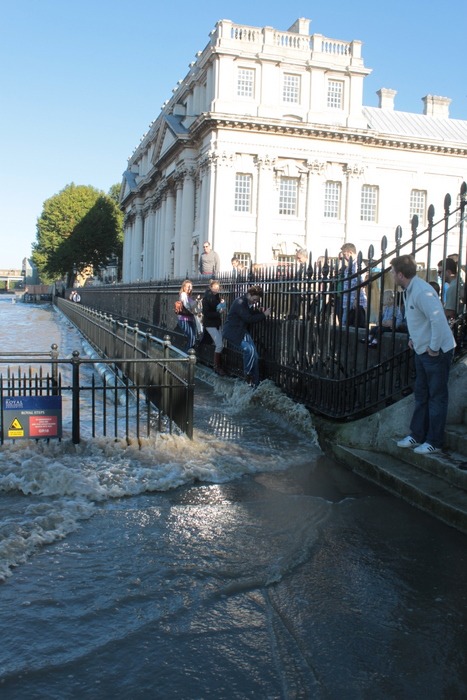
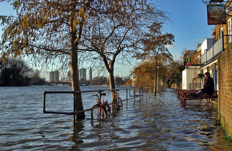
Five-Foot Flooded walkway by the River Thames in front of Greenwich University


The level of the Five Foot Walk in front of Greenwich Hospital (now Greenwich University) is just above the mean high tide level of the River Thames and about 1 metre below the flood defense level in this part of London. It therefore enjoys frequent floods – as do those who use the walkway. They run, jump, climb and carry each other through the water (more often boys carrying girls than the other way about for some reason). Despite this wonderful example, all the new walks beside the Thames are built high above the flood defense level. This costs more money and separates people from the water margin where, in Desmond Morris’ view, their ancestors evolved. And the separation is ugly.
The name Five Foot Walk is a reminder that the commissioners of Greenwich Hospital did not want any public access in front of their fine buildings but, after a long battle, were forced to concede a walk with a maximum width of Five Feet (1.52m). No problem – it is wide enough almost every day of the year. But post-Abercrombie riverside walks tend to be 5-7m wide. Why? Because the town planners are unobservant nutters who know so little about landscape architecture that they see no need for expert advice. See note on London’s Riverside Landscape (Abercrombie’s diagram is at the foot of the page). I speak as an ex-Town Planner – who proudly resigned from the Royal Town Planning Institute (RTPI) because the organization was devoid of idealism and imagination. It reminded me of a local government trades union and it was a great relief when the RTPI Journal stopped squirming into my letter box.

The geography and topography of place

Urban designers in the port city of Copenhagen are making quite a splash for themselves with the design of several exciting new urban spaces.

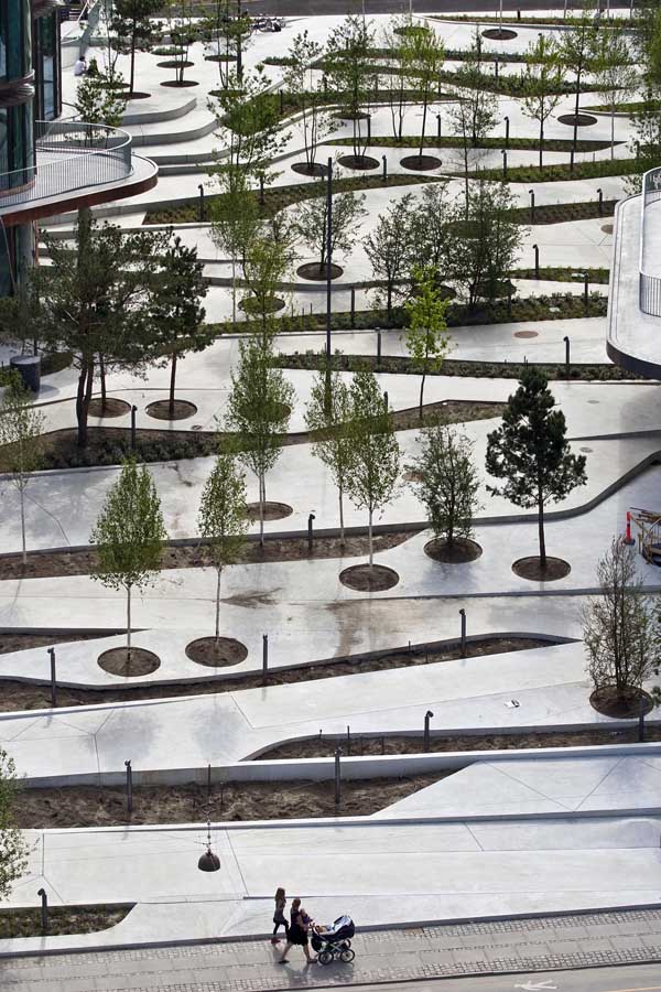
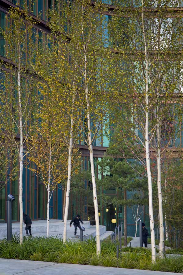
Dune city is the latest urban design offering by SLA in Copenhagen. “Like a giant dune of sand or snow it slips in between and clings around the buildings, thereby creating a spatial coherence in the design.”

The foldedplate design enables the visitor (pedestrians, cyclists, skaters and the walking impaired) to tranverse the elevated landscape between the buildings amidst a vegetated space of reedy grasses and trees. The landscape has been designed to appear flat and two dimensional from a distance but to reveal its true three dimensional character as you move through its spaces. The high albredo effect is said to produce a cooler microclimate during the warmer periods by reflecting the incoming heat and radiation.

Can the the world’s model climate citizen lead the way also with climate sensitive urban design and by its example also change the fate of nations like Mongolia?

Waffle cities: landscape planning, urban design and architecture for flood-prone regions and global warming

Long term landscape planning for the type of floods which have afflicted Australia could involve designing the landscape in the manner of a regional waffle. Much of the problem seems to have been caused by flows of water on an almost continental scale. The principles, as for Sustainable Urban Drainage Schemes, (SUDS) should be to detain, infiltrate and evapo-transpire flood waters. This process would be assisted by raising embankments where possible: field boundaries, roads, garden boundaries etc should all become dykes. In some cases the dykes would protect against floods but the main objective would be to stop the flood water cascading from zone to zone. Also, the dykes would serve as wild-life corridors and sanctuaries. My guess is that waffle-type measures would be cheaper and more effective than building large dams. The next stage would be to move from flood landscape planning to flood landscape architecture, by finding other uses for the dykes and by making them beautiful as well as useful. Individual properties would gain some similarities to motte-and-bailey Norman castles. Another advantage of waffle landscape planning is that when the rains come there will be more time for water to infiltrate into the ground and re-charge aquifers – in preparation for the next long period of drought. Does anyone know if waffle landscape planning has been considered, and if the engineering calculations have been done?

Image courtesy mhaithaca

Saving the prickly and cute…

…And all creatures great and small.

Having recently experienced the flooding of my city I am keen to help some of the less visible victims as well. Having spotted a dead echidna by a tree next to a usually busy road in a flood affected inner city suburb, and realizing that he was most probably washed there in the flood waters from Toowoomba, I am keen to start an online charity to assist wildlife.

I am proposing an Ark Appeal for Wildlife. Would gardenvisit be happy to sponsor a charity and gardenvisit readers happy to contribute to it?

Flooded urban landscapes are frightening, beautiful, and a call to action by the landscape, architecture and urban design professions

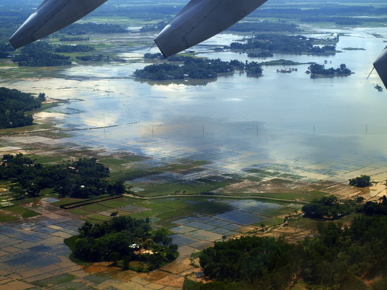
A terrible thing happened to Pakistan, reminding us of the Sumerian Flood Tablets and the flood of the Old Testament (which may refer the same flood). The ancient floods were seen as a call to humans to change their ways – and so should the great Indus Flood of 2010, the great Australian flood of 2011, the great Brazilian flood of 2011 and the great Sri Lankan flood of 2011 . As the aerial photograph shows, Pakistan is largely desert. Would it have been possible to divert the flood waters onto barren land? If so, it might have done a lot of good and might have let us enjoy the great potential beauty of flooded landscapes. The issues involved have much greater significance than the geographic extent of Pakistan: they concern us all. We need to learn, perhaps from the baolis and hauz of India and Pakistan, how to store flood waters and use them over extended periods of time. Every human-used landscape should have plans for floods with return periods of 1-year, 5-years, 25-years, 100-years, 1000-years etc. See diagram for a modest suggestion on how to plan the management of flood landscapes.
What can urban designers do to design for flood resistance? They can exercise their imagination in flood design competitions and contribute to flood charities. Professional people should so some work for money and some work for love. We need floodable buildings, floodable gardens and floodable parks. The photograph below shows part of London (Strand on the Green) where regular flooding is expected, planned-for and enjoyed.
Top image courtesy Richard