Category Archives: urban design flooding

Flood protection bunds: the waffle method and the chickens coming home to roost

Catal_huyuk_somerset_levels
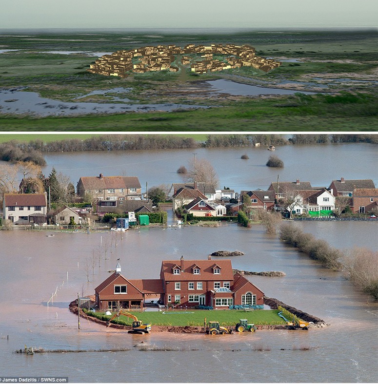
What goes around comes around. The top image is a reconstruction of one of the world’s oldest settlements, at Catal Huyuk in Turkey. Ancient Chinese cities were also protected from floods by high walls. The lower image (from yesterday’s Daily Mail) shows a builder’s determination to protect himself from the floods which have engulfed the Somerset Levels in 2014. See previous posts about the Waffle Method of protecting property from floods. This is what I would do if I lived in a flood-prone area: take my own flood-protection measures. I would of course have no objection to taxpayers building levees and digging channels to protect my property – but I would not trust their generosity. Here is another example of waffle-flood-protection in the flood plain of the Mississippi. Knowing that climate change is taking place, despite Prince Charles’ view of my stupidity, I would build the bund into the design of my garden rather than waiting until the flood waters crept up on my boundary. The bund would also protect the chickens-with-heads I would like to keep in my country garden. Since it would be protected against foxes I could let them enjoy a free-range lifestyle and roost in the trees in my country garden. One other thing: if I was a wealthy builder I would employ a garden designer for my private paradise in Somerset.

Korea's Four Rivers Landscape Restoration Plan

Korea's Four Major Rivers Landscape 'Restoration' Project

Korea's Four Major Rivers Landscape 'Restoration' Project

Having completed a remarkable river landscape reclamation plan for the Cheonggyecheon, Korea now plans to ‘restore’ four more rivers. I put ‘restore’ in quotation marks because the intention is to more forwards instead of backwards. This may be the correct policy but it is surely the wrong verb. Korea has a commendably ambitious Green Growth Policy which sees greening the environment as productive of economic benefits.
The map (kindly supplied by the Ministry of Land, Transport and Maritime Affairs, Korea) has the curious effect of representing the Korean Peninsula as an island. Is it saying ‘China, go hang’? I am delighted that each of the rivers is marked as a cycle route. We should all learn from Korea’s national landscape strategy.

Waffle levee flood planning for the Mississippi

I was pleased to see that our post on Waffle cities: landscape planning, urban design and architecture for flood-prone regions and global warming has been verified as feasible. The snippet (courtesy of London Evening Standard 20.05.2011) shows that a homeowner in Vicksburg has made his home into the ‘cell of a waffle’ and that the self-build levee protected his home from the Mississippi floods of spring 2011. Congratulations!

Is new urbanism old?

The 10 principles of New Urbanism are:

1. Walkability
2. Connectivity
3. Mixed use and diversity
4. Mixed housing
5. Quality architecture and urban design
6. Traditional neighbourhood structure
7. Increased density
8. Smart transportation
9. Sustainability
10. Quality of life

According the wikipedia entry “This new system of development, with its rigorous separation of uses, became known as “conventional suburban development” or pejoratively as urban sprawl, arose after World War II. The majority of U.S. citizens now live in suburban communities built in the last fifty years, and automobile use per capita has soared.

Although New Urbanism as an organized movement would only arise later, a number of activists and thinkers soon began to criticize the modernist planning techniques being put into practice. Social philosopher and historian Lewis Mumford criticized the “anti-urban” development of post-war America. The Death and Life of Great American Cities, written by Jane Jacobs in the early 1960s, called for planners to reconsider the single-use housing projects, large car-dependent thoroughfares, and segregated commercial centers that had become the “norm.”

Rooted in these early dissenters, New Urbanism emerged in the 1970s and 80s with the urban visions and theoretical models for the reconstruction of the “European” city proposed by architect Leon Krier, and the “pattern language” theories of Christopher Alexander.”

New urbanism was fundamentally a social planning movement although it has morphed more recently to include at least a minimalist environmental agenda. Wendy Morris says new urbanism was “….Initially A Reaction to Sprawl…..Now A Basis for Sustainable Urban Growth/Smart Growth…….and a response to Climate Change and Peak Oil…and a Basis for Addressing Physical Health and
Social Well-being.”

Can the old theory of New Urbanism be adapted to adequately address new environmental concerns?

Five-Foot Flooded walkway by the River Thames in front of Greenwich University


The level of the Five Foot Walk in front of Greenwich Hospital (now Greenwich University) is just above the mean high tide level of the River Thames and about 1 metre below the flood defense level in this part of London. It therefore enjoys frequent floods – as do those who use the walkway. They run, jump, climb and carry each other through the water (more often boys carrying girls than the other way about for some reason). Despite this wonderful example, all the new walks beside the Thames are built high above the flood defense level. This costs more money and separates people from the water margin where, in Desmond Morris’ view, their ancestors evolved. And the separation is ugly.
The name Five Foot Walk is a reminder that the commissioners of Greenwich Hospital did not want any public access in front of their fine buildings but, after a long battle, were forced to concede a walk with a maximum width of Five Feet (1.52m). No problem – it is wide enough almost every day of the year. But post-Abercrombie riverside walks tend to be 5-7m wide. Why? Because the town planners are unobservant nutters who know so little about landscape architecture that they see no need for expert advice. See note on London’s Riverside Landscape (Abercrombie’s diagram is at the foot of the page). I speak as an ex-Town Planner – who proudly resigned from the Royal Town Planning Institute (RTPI) because the organization was devoid of idealism and imagination. It reminded me of a local government trades union and it was a great relief when the RTPI Journal stopped squirming into my letter box.

Getting wet: staying on the edge

As we await two expected tropical cyclones in North Queensland the following questions have a particular poignancy. What is the solution to coast inundation? Are there ways in which we can get used to getting wet and enjoy it as part of the experience – akin to playing in the surf?

While the Israeli port project may not offer the solution to the landfall of tropical cyclones, it might inspire ways to accommodate a slightly less defined and changeable boundary between the sea and land.

Mayslits Kassif Architects urban regeneration of the Tel Aviv Port is a landmark project which saw “the suspension of all the area’s rezoning plans” and set a precedent for “transformation not propelled by building rights, but by a unique urban design strategy.” The project received the 2010 Rosa Barba European Landscape Prize.