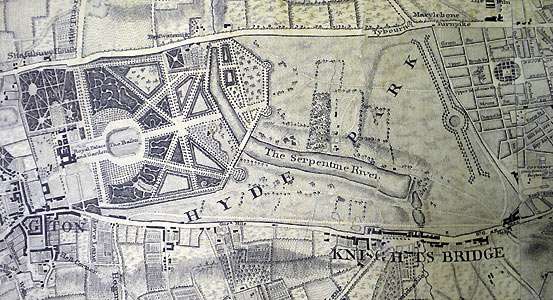
In 1730 Queen Charlotte ordered the damming of the Westbourne River as part of a general redevelopment of Hyde Park and Kennsington Gardens by Charles Bridgeman. The Serpentine Lake in Hyde Park is the remnant of the Westbourne River which since 1850 has been diverted into a culvert and runs into the Thames near Chelsea. “The Serpentine Lake was one of the earliest artificial lakes designed to appear natural” and was widely imitated. The Long Water because of its relatively undisturbed nature is a significant wildlife habitat.
Hyde Park and its surrounds has changed considerably since its inception. Contextualising the statute of Achilles by Richard Westmacott which was said to have originated in the classical taste of the Countess Spencer, demonstrates the remarkable changes that have taken place both in the use of the park and in the urban environment which surrounds it. The Queen and Prince Albert are drawn taking air in their carriage as they pass by the statute c1840.
Achilles meanwhile remains a most admired archetypical hero.
I like GIS generated maps but it will be a terrible pity if the hand-drawn map disappears. John Rocque’s map captures the mood of 1737-47 London in a special way. Googlemaps etc will capture the London of 2010 even better, but it won’t be in the SAME way!
Hyde Park has never had a conventional landscape masterplan – and this seems to have had advantages. Lots of people have done things to it which a plan might have prevented, eg swimming in the Serpentine and horse-riding on Rotton Row.
I wonder whether the damming of the Westbourne was the cause of it becoming polluted? Apparently since 1834 water has been puumped from the Thames to supply the Serpentine lake.
Perhaps a urban waterways rejuvenation project would be a good idea? Could the Westborne be saved from its underground diversion? [ http://www.inhabitat.com/images/london_drain_1.jpg ]
With the beauty of Pisarro’s painting showing the glory of Hyde Park
[ http://upload.wikimedia.org/wikipedia/commons/4/4f/Pissarro_Hyde_Park.jpg ]perhaps there is potential in a new urban plan for the Westbourne and its role in the park and surrounding urban areas?
The original flow of the Westbourne was diverted into the Ranleagh Sewer. And yes definitely re the restoration of the Westbourne to Pisarro quality. I think the intention should be stated in a London Plan, without worrying too much about the when or the how. They could just find one tiny gesture project to set the idea in motion and then invite everyone and anyone to make additional gestures until an unstoppable flood begins to flow.
Here is a map of London in 1593. It would be interesting to colour in any features which are still exactant.
[ http://4.bp.blogspot.com/_PjMVCKQDVg0/SqJDBkP5FyI/AAAAAAAAKEk/JgioidOemMQ/s1600-h/river+fleet+1593+map_of_Westminster.jpg ]
Here are some more old London maps. You can already overlay the old OS maps with modern maps with GIS and it would be very interesting to take the process back by rectifying the old maps.
London by Norden 1593.
[ http://freepages.genealogy.rootsweb.ancestry.com/~genmaps/genfiles/COU_files/ENG/LON/Norden_london_1593.htm ]
London by Van der Keer 1593.
[ http://freepages.genealogy.rootsweb.ancestry.com/~genmaps/genfiles/COU_files/ENG/LON/vandekeere_lon_1593.html ]
Look reasonably similar, and much more populated than the previous 1593 map. It must be earlier. Perhaps more like 1563?
Then again the two maps of 1560 don’t look like the same London time either. What do you think?
Perhaps it might be worth beginning with London in 1300?
[ http://en.wikipedia.org/wiki/File:London_1300_Historical_Atlas_William_R_Shepherd_(died_1934).PNG ]
Oh, sorry, Westminister took some time to be incorporated into London. The Agas (1570-1605) map is more helpful, to the growth of London and development along the Thames.
[ http://upload.wikimedia.org/wikipedia/commons/5/5f/Civitas_Londinium_or_The_Agas_Map_of_London.jpg ]
Yes: I think the Agas map is the most useful, especially for garden historians, and it would be great fun to walk round the city with sections of the map overlaid with modern GIS data.
They marked out the line of the Meridian in Greenwich park a few years ago and I would also like to see the courses of London’s underground ‘Lost’ Rivers marked on the surface or even echoed with modern swales etc.
Perhaps you could take a photograph of the view of London from Greenwich [ http://www.garwood-voigt.com/catalogues/H19835LondonGreenwich.jpg ]at One Tree Hill? [ http://www.garwood-voigt.com/catalogues/H25772GreenwichGentleman.jpg ].
It seem this map by James Wylde in 1842 represents the area in which Hyde Park is located after the Serpentine Lake was created (1730) but before it was diverted into a culvert (1850).
[ http://www.garwood-voigt.com/catalogues/H210781LondonWyld.jpg ]