
Sunrise on the solstice is celebrated at Stonehenge. Archaeologists now think sunset was the significant occasion.
Image courtesy tarotastic
Sunrise on the solstice is celebrated at Stonehenge. Archaeologists now think sunset was the significant occasion.
Image courtesy tarotastic
It is likely that the history of Japanese gardens finds its origins in Shinto traditions. In particular the sacred nature of rocks: “from the ancient remains of rock arrangement” of the fifth century AD, we find a resemblance to existing Japanese gardens. “However it appears they were used for the spiritual rituals and not designed as a stone arrangement for the beauty of gardens.”
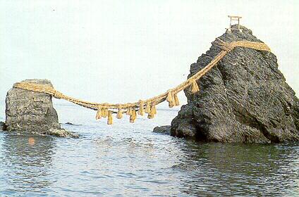
The earliest known Japanese gardening texts are a medieval text, Sakuteiki, and an illustrated text dating from the Muromachi period (1333-1573). The origins of Japanese garden design principles are said to be traceable back to these two texts. The location of Shinto shrines were near striking natural formations, waterfalls, caves, rock formations, mountain tops or forrest glens reflecting the idea that kami spirits were located in nature. The earliest shrines were mounds, caves or groves. Kami occur in two categories (object kami) and mythical and historical persons (active kami). Illustrated is off-shore rock kami.
The following story is related of an off-shore rock just off Oshima:
“The kami enshrined here is Ichikishimahime, daughter of Susano, and eldest of the three Munakata princesses. Just off Oshima is a large rock protuding from the sea. The story is when Ichikishimahime heard she was going to be enshrined on Oshima, she was really excited and proud because Oshima means ‘Great Island’, but when she got here and saw just how small it really was, her tears formed the rock.”
With the introduction of Buddhism into Japan the earliest interaction saw local kami asking to be saved from their kami-state by means of Buddhist ritual.

John Evelyn's garden superimposed on plans of the Convoys Wharf site in the seventeenth century, the nineteenth century and, one hopes not, the twentyfirst century

This drawing purports to show 'Landscape, Townscape and Visual Amenity' . Phooey
 Better not to name it, for fear of attracting more tourists, but this is a silk road city in Central Asia. It was opened up by archaeologists and then left in this condition. The excavators will have published a learned report on their findings. Then they left it like this – as a tourist attraction which the government can put into guidbooks, hoping to create jobs and attract hard currency which can be spent on weapons. Now the rain falls on the mud walls, the sun cracks them, the wind blows the dust away. Far better if the archaeologists had done something useful with their lives, instead of running university courses to teach other archaeologists to support the tourist industry.

The floods have done something amazing to the inland Australian landscape that is perhaps only rivalled by the fabulously unique underwater landscapes that are rarely glimpsed by the landbound. It is a rare event that mostly only occurs in La Nina weather patterns: the overflowing of Lake Eyre.
And where is all this additional water coming from? Tropical cyclones, with their destructive winds, which develop over the Pacific Ocean as far away as Fiji. So out of natural disaster (as we call it because of our cities and human settlement patterns) comes a natural wonder.
Is there a better way for us to accommodate the cycles of nature within our human environments?
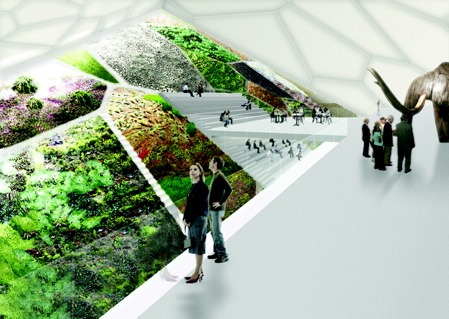
It is not often that you see a proposal for a substantial indoor garden, still less one located on an ice tundra, however this is what Leeser Architecture, (who also imagined the engaging Helix Hotel in Abu Dhabi) have proposed in their design for the World Mammoth and Permafrost Museum in Yakutsk Siberia. Yakutsk is the world’s largest city built on permafrost with temperatures ranging from -45degF to 90degF.
The extensive and intensive indoor gardens have been designed to “promote a sense of year-round natural life even in the desolate winter months.”
Not much is said of the about the construction of the landscape elements and gardens. This is a competition afterall, so details will undoubtedly be required later.
The exterior gardens are described as “naturally patterned by the effects of shifting permafrost cycles.” Cells will be planted with native grasses. Mosses and trees will be reintroduced to the landscape to reflect the existing topography and improve site hydrology.
While the interior gardens cascade “at the perimeter of the building’s interior with lush thick mats of moss and lichen” grown between a latticework of pathways.” Moss and lichen are the natural insulators of permafrost ground. The gardens have a number of important functions including to 1) add color 2) insulation value 3) filter indoor air and 4) maintain air humidity.
In one of the gardens floats a cafe, while other gardens can only be viewed from above by visitors but are accessible to researchers.