Computer-based Geographic Information Systems (GIS) have the potential to revitalise planning, when they are used as conceptual models, rather than maps or decision-making tools.
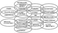
Fig 1.18 A GIS enables relationships between land uses to be mapped and analyzed as a set of Venn diagrams
Geography made planning possible and geography is set to revolutionise planning, especially landscape planning. The GIS will allow a host of new messages to be heard and spoken. It assists multi-purpose planning by allowing the relationships between land uses to be recorded and analysed [Fig 1.18]. McLuhan's dictum that 'the medium is the massage', related to the successive impacts of printing, radio, film and television on society. They led to new ways of seeing, understanding, influencing and controlling the world. So will Geographical Information Systems.
Fig 1.19 A GIS is a spatial database. Areas on a map are produced from database tables, and vice-versa.
A GIS is a computer-based system for storing, retrieving and analyzing geographical information. Like its famous predecessor, the map, it is a store of data [Fig 1.19]. Spatial information can be held as points, lines and areas, defined by co-ordinate geometry. Unlike the 'map', a GIS permits rapid modification and the reproduction of plans, at any scale, with extraordinary precision. Non-spatial information, known as attribute data, can be held as words and figures. Subject to the constraints of data collection, data storage and data processing, a GIS allows the physical world to be 'mapped' in any number of ways for any number of purposes. Readers who have used a spreadsheet but not a GIS may find an analogy helpful. If a TV screen or a newspaper photograph is enlarged, it will be found to comprise a large number of dots, known as pixels. These dots can be thought of as the cells of a spreadsheet or database programme. On a TV screen, the dots receive information on colours. In a GIS, they can also contain other types of information: heights, temperatures, pressures, population statistics, soil types, plant species, animal species, anything. Like the information which is displayed on a TV, GIS data can be stored digitally on magnetic media. It can then be recalled whenever it is wanted and displayed in fresh combinations.