When a new technology becomes available, it is often used, in the first instance, to do the same job as an older technology. Early printing presses were used to print bibles; the first automobiles were treated like horse-drawn carriages; the first tanks were used as mobile guns. But it is also possible to use new technologies in new ways. This is the challenge. The GIS will do for landscape planning what the pocket calculator did for arithmetic: it will make previously complicated operations easy to perform. But a GIS will not convert planning from an art of judgement into a deductive science. As with any computer system, there is a direct relationship between inputs and outputs. Facts-in, facts-out. Values-in, values-out. Wisdom-in, wisdom out. Garbage-in, garbage-out.
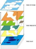
GI Systems will provide new conceptual models which will help us to think about planning. Like physical models [Fig 1.20], they can represent the past or the future. Physical models display shapes and colours. GIS models can show all sorts of other qualities: traffic, water flows, air flows, materials, vegetation, population, property values: any topic on which data is available. For each layer, the GIS can show both the existing situation, a predicted situation and a proposed future condition. GI Systems can also store the information which land managers use.
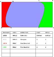
[Fig 1.21] A GIS can store the information which administrators and businesses require. This diagram shows the type of information required by park managers.
Diagrams in textbooks often represent a GIS as a glass box with a series of layers. If the GIS is to contain only information about the existing landscape, this is a reasonable analogy. The date of information collection is the date on the box. But if the GIS also deals with future plans, then a tank of water is a better analogy, with new material arriving all the time. Better still, imagine a column reaching up through the earth's bedrock, on through the sea, up towards the outer atmosphere.
[Fig 1.22] A GIS can be used to model the past, the present and the future.
Layer upon layer of material arrives, sinks gradually through the swirling airs and waters to form the existing landscape. High above are the forces of nature, human intentions and dreams. Some will settle, others will be swept away. Pre-GIS planning used only two layers: one for the existing landscape and one for the proposed landscape.
Post-GIS planning will be multi-dimensional and multi-layered. 'Plans' will be able to reach high levels of indefinability. Metaphorically, they will lie below the seabed and above the waves. Health can be partially defined by quantifiable measures: temperature, pulse rate, cholesterol levels, physical strength and so forth. But these are 'seabed' measures and they are not the only measures. Spiritual, social and mental states also contribute to good health and to a good environment.
In many countries the environmental impact assessment system is separate from the planning system. GIS has the technical capability to integrate the two systems. It should become easy to ask zoning, location and impact questions. A further strength of GIS is that information from photography and remote sensing can be utilized. But the real significance of GI Systems is conceptual. They model the environment and help us to think about development and the environment.
Although computer memories can be vast, GIS models will always be small in relation to the complexity of the real world. The only accurate model of the world is the world itself. Individual atoms, protons and neutrons, which would have to be referenced in a 'complete' GIS model, are placed into colossal categories: hill, town, house, meadow, farm, bog, forest. The categories, known as entities or objects in a GIS, are chosen because of the ways in which humans live. Other animals and other human societies would have different ways of categorising the world. If hedgehogs could set up a GIS, one surmises their categories would be based on olfactory perceptions of food, safety and sex.
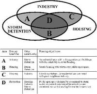
Classifications are always made for a purpose. At present there are strict limits, imposed by laws and the limitations of maps and mapping conventions, on what can be shown on approved town plans. Only the 'most important' land uses appear: housing, industry, roads, commercial areas and parks. When computer-based geographical information systems replace maps, there will be fewer restraints on what is mapped, planned and designed. Planning-on-paper will be replaced with planning-by-database.
[Fig 1.23] A GIS can be used to model the past, the present and the future.