- England
- Scotland
- France
- Holland
- Germany
- Italy
- Spain
- Portugal
- USA
- China
- Japan
- India
- Iran
- Advice
- Gardens
- England
- Scotland
- France
- Holland
- Germany
- Italy
- Spain
- Portugal
- USA
- China
- Japan
- India
- Iran
- Advice
- Garden Tours
Book: Landscape Planning and Environmental Impact Design: from EIA to EID
Chapter: Chapter 9 River engineering, channelization and floods
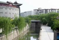
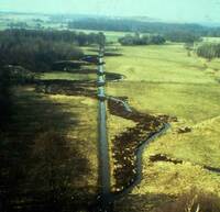
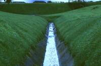
Channelized watercourses must now be reclaimed as 'rivers'.
Dunne and Leopold use the Sammamish Slough to illustrate the point. The channel was graded to engineering profiles, sown with grass seed, and sprayed with herbicides to keep down trees and shrubs. After a decade of this treatment a firm of landscape architects was hired 'to plant trees along its banks, halt the spraying, grade the banks to a shallower angle, and encourage the development of wildlife habitat and public access'. It was done without reducing the conveyance capacity of the channel. Another reclamation project, which I love, is described in a special streams issue of Garten & Landschaft. The River Wandse, where it runs through a nature reserve, was reclaimed from a rullerï¾straight engineered channel, and restored to its old meandering course, which was plotted from old maps and by searching the ground for moisture indicating plants [Fig 9.6]. Truncated sections of the linear channel were retained as wetland habitats (Glitz 1983). In Denmark, the Watercourse Act of 1949 stated that 'drainage shall have priority over any other use' (Brookes, 1988:17). The government agency with responsibility for land drainage worked with great efficiency and by 1997.8% of Danish watercourses had been straightened. This was a higher proportion than in any other European country [Fig 9.7]. Eventually, after a campaign by conservationists, the process was put into reverse, the same government agency having responsibility for the work. Straight rivers (ᆭ) are being re-converted to serpentine rivers (S) and a dollar sign ($) is used, by wits, to summarise the situation. The history of British river engineering practice in the second half of the twentieth century is illustrated by London's rivers, with the River Lea a good example. It was once Izaak Walton's favourite fishing river. A downstream channel enlargement project, started in 1948, was seen as 'the first instalment of a comprehensive concept for the improvement of the River Lea' [my italics] (Association of River Authorities 1965). The second instalment, below Chalk Bridge, was a grim concrete flood relief channel lined by chainlink fences [Fig 9.8]. It could persuade the most determined sceptic of the need for environmental impact design. The third instalment, from Chalk Bridge to Ware, looks like a canal, because weirs and sluices retain the water at topï¾ofï¾bank level, and had a detrimental impact on wild life. One part of a fourth instalment, on a tributary of the Lea, was carried out with more care for wildlife but further work was blocked by pressure from conservation groups and the Nature Conservancy Council. Comprehensive landscape improvement schemes are needed for the work which was carried out on the Lea from 1948ï¾1976, and for all London's rivers ï¾ especially The Roding, The Cray, The Ravensbourne, The Wandle [Fig 9.9], The Beverly Brook, the Quaggy and, of course, The Thames itself. Gone are the days when a poet could pen a river stanza for the Chronicle of London: Above all rivers thy river hath renown Whose beryl streames, pleasant and preclare Under thy lusty walles runneth down; Where many a swan doth swim with winges fair, Where many a barge doth sail, and row with oar, Where many a ship doth rest woth top-royal. O town of townes, patron and not compare, London, thou art the flower of Cities all. (William Dunbar 1465-1530) At some happy point in the future, it may become possible to follow the melancholy book on The lost rivers of London (Barton 1962) with a triumphalist sequel: How we won back London's rivers.