- England
- Scotland
- France
- Holland
- Germany
- Italy
- Spain
- Portugal
- USA
- China
- Japan
- India
- Iran
- Advice
- Gardens
- England
- Scotland
- France
- Holland
- Germany
- Italy
- Spain
- Portugal
- USA
- China
- Japan
- India
- Iran
- Advice
- Garden Tours
Book: Landscape Planning and Environmental Impact Design: from EIA to EID
Chapter: Chapter 7 Agriculture, farming and countryside policy
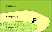
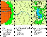
There is a geographical variation in the range of public goods which can and should be obtained from the countryside. Some land is suited to olives, some to wheat, some to paw paws, some to cabbages. It is the same with public goods: different regions are geographically suited to the provision of different goods [Fig 7.16]. 7.16 Different types of countryside can supply different types of public good. Yet the existence of a market for public goods depends as much upon demand as supply. Demand is likely to be greatest near population centres and in areas of outstanding scenic quality, such as coasts and mountains. The geography of public goods can be considered at various scales: a farm, a nation state, a continent. A mixed farm in England [Fig 7.17] will have a range of farmland types: 7.17 Land can be categorised at the farm scale Category A. Deep and well-drained land which is ploughed for arable crops. Category B. Thinner and stonier soils which are used for grazing. Category C. Steeper banks which are left for woodland and wild animals, some of which are hunted for game. As the prosperity of farming rises and falls, the proportions of land placed in the three categories will rise and fall for private financial reasons. If a communal agency seeks to purchase public goods from the farmer, then the category of land which is employed for the purpose will depend on the type of good. Category A land can provide a strategic reserve for food production. Category B land may be important for scenic conservation and Category C land for nature conservation. Comparable policies can be applied at the scale of a nation-state. In Britain, there is a marked difference between Ancient Countryside and Planned Countryside. Ancient Countryside is characterised by mixed hedge species, ancient trees, sunken roads and antiquities [Fig 7.18]. It tends to have a pattern of hamlets and towns. Planned Countryside is 'in the main, a mass-produced, drawing-board landscape, hurriedly laid out parish by parish under Enclosure Acts in the eighteenth and nineteenth centuries' (Rackham 1990:5). It would be possible to use Planned Countryside as a production zone and Ancient Countryside as a conservation/recreation zone. Intermediate land could be used as a strategic reserve. Policies of this type could also be applied to Europe, which has a Common Agricultural Policy (CAP). Three categories of land are shown on the map [Fig 7.19]. 7.19 Land can be categorised at the European scale Category A land is an openfield, or former openfield, landscape, well suited to providing a strategic reserve for food production. Its use-intensity can be lowered for decades and raised when required. Public finance should be used to protect productive land from urbanisation and afforestation. Category B land is a predominantly enclosed landscape with stone walls, ancient pastures, field trees, shepherds huts and other structures of historic interest. Public finance should be used to support the agricultural practices which maintain these features. Category C land is a Mediterranean openfield landscape with tree crops and horticultural production. Public finance should be used for scenic protection and to maintain a strategic horticultural capability. At this scale of planning, the consequences of a simplistic policy become apparent. Some regions, and even countries, could cease to have any significant level of agricultural production. This consideration dissuaded Switzerland and Norway from joining the European Union. Other countries, like France and Germany, would have large concentrations of people surrounded by intensively managed farmland. Decisions about the purchase of countryside public goods need to be taken at each level of decision-making. If a United Nations agency sees particular habitats, artifacts or agricultural practices as part of the world's heritage, it should give them financial support. European, National, Regional, Local and Community bodies can follow the same principle. There is great advantage in different agencies viewing the problem from different vantage points. But they should all be careful about zoning. In both urban and rural areas, it tends to produce visual monotony and functional inefficiency. And there are innumerable problems of definition and classification. Simplistic zoning results in society paying for all sorts of public goods it does not require.