- England
- Scotland
- France
- Holland
- Germany
- Italy
- Spain
- Portugal
- USA
- China
- Japan
- India
- Iran
- Advice
- Gardens
- England
- Scotland
- France
- Holland
- Germany
- Italy
- Spain
- Portugal
- USA
- China
- Japan
- India
- Iran
- Advice
- Garden Tours
Book: Landscape Planning and Environmental Impact Design: from EIA to EID
Chapter: Chapter 3 Context sensitive design theory
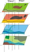
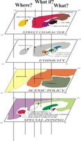
A GIS can assist in checking the impact of development projects upon natural, social and aesthetic aspects of the context. It provides the data for co-ordinating the environmental assessment and land use planning systems. In order to produce good contextual designs, it is necessary to have good information on: -environmental history (eg former habitats, former watercourses, archaeology, ancient farming patterns) -present environmental conditions (eg soils, vegetation, hydrology, land use, visual character, Alexander patterns, street patterns) -plans for the future environment (eg plans for habitat creation, scenic improvement, greenspace, river reclamation, recreational development and urbanisation) This information should be available in an Environmental Planning Database (EPD), or Planning Information System (PIS). A GIS displays structures of different kinds. The 'lower' layers of the model represent historic conditions. The 'middle' layers show the existing situation. The 'upper' layers represent possible future states of affairs. An EPD is good at answering contextual questions, typically about What?, Where?, and What if? For example: Impact questions: What happens if it goes there? What is the impact on each aspect of the landscape? Zoning questions:What is this area notable for? What is this area suitable for? What special considerations apply to this area of land? Which areas of land are homogeneous? Location questions: Where are the location criteria satisfied? Which is the most scenic route? Which area has the lowest scenic quality? Such questions relate to the past, present and future of the environment. By asking 'What, Where and What if' questions, a GIS can bind the land use planning system to the environmental assessment system [Fig 3.20]. Fig 3.20a and Fig 3.20b Geographical Information Systems use layered models. They can represent the natural environment (left) and the social environment (right) and are good at providing answers to What?, Where?, and What if? questions. The GIS offers flexibility, vast data storage and analytical capabilities. It can also facilitate community involvement in the planning process, as can be explained with a recondite example. Let us assume there is a local Hedgehog Society. Members of the society can draw information from the GIS database, conduct surveys, formulate a plan and lodge it in the GIS. When a new road is being planned, the highway planners will query the GIS about the impact of their proposal on the existing environment and on the community's aspirations. This will reveal that an area which they took to be 'waste land' is actually an important hedgehog habitat with rotting brushwood, warm places to nest and good supplies of black crunchy beetles. Road engineers can diminish opposition to their plans by promising to manage new embankments as hedgehog habitats. We could have a low roadside fence to stop hedgehogs straying onto the highway. Other layers of the GIS can deal with other aspects of the wood. On a two dimensional map, existing trees would be represented by patches of green and the proposed management zone by a red line. A well-balanced EPD can go much further, by providing information and predicting the impact of alternative development scenarios. It can show the distribution of plant and animal species in the wood, proposals for water conservation and management, the location of scenic areas, the role of the wood in screening a nearby quarry, the areas of wood which are used for children's play, and the places where orchids grow. Once the information has been lodged in the computer, a query about a parcel of land will reveal the data which has been collected and the plans of different community groups. Good information is the essential foundation for good environmental planning and design. The GIS cannot, of itself, answer the question of whether the Australian's project should be given the go-ahead. But it can make available the information on which to base a contextually appropriate decision. This may include: - a long-term agricultural plan to de-emphasise food production on the urban fringe, - a recreation plan showing an intention to develop the recreation and tourism potential of the area - a survey showing that the existing plants and animals in the area are not important for reasons of scarcity or diversity - a scenic quality assessment showing that the area is of medium to low scenic quality -a water management plan showing a need to increase surface water infiltration in the area All these factors would tend to support the Australian's application. He would have a better chance of a fair hearing if the planning and development context was defined in a Strategic Plan and Strategic Environmental Assessment before his application was made. Surveys and plans made in response to particular applications tend to be biased.