Modern use-categories should be deconstructed
The arrangement of land uses can be subject to philosophical analysis, aided by Venn diagrams, structuralist and deconstructionist concepts.
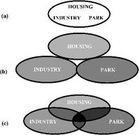
Venn diagrams were devised by an English logician, John Venn, as a means of representing classes and logical statements pictorially. Circles, or elipses, are used to depict categories and relationships between categories. Thus: an isolated circle can depict a single land-use; the overlap between two circles an area which has two land uses; the overlap between three circles an area which has three land uses. The relationship between Venn diagrams, overlay maps and database tables is shown by Figs 2.12].
Fig 1.13 Three alternative ways of arranging land uses, shown by Venn diagrams: (a) mixed, (b) singular zoning, (c) plural zoning.
Before the age of planning, land uses were mixed indiscriminately [Fig 1.13a]. If someone built a tannery or a blacksmith's shop next to your home, this was unfortunate: the former gave off a sickening ordure and the latter a devil's rattle. In the early days of planning, problems of 'negative side effects', or pollution, were solved by single-use zoning [Fig 1.13b]. Today, the aim is to allow 'good neighbour' land uses to enjoy a beneficial relationship [Fig 1.13c] and to place 'bad neighbour' land uses in industrial zones. The task of fitting land uses together and forming harmonious relationships requires skill and ingenuity, as does match-making between people. The first step is a review of each project to discover the potential for:
-adaptation to the production of public goods [see Chapter 2]
-adaption to neighbouring land uses and the local context [see Chapter 3]
As discussed in the preceding section, the use of scientific procedures led to an emphasis on single-use planning. This was a cause of urban sprawl [Fig 1.14]. It also tended to produce a hierarchical relationship between land uses: roads have a privileged relationship to planning; planning to architecture; architecture to landscape architecture; flood control to nature conservation; forestry to amenity. The way in which these land uses are planned and designed is a 'sign' which reveals underlying social structures. They are structures which can be interpreted with the aid of two philosophical approaches: structuralism and deconstruction.