- England
- Scotland
- France
- Holland
- Germany
- Italy
- Spain
- Portugal
- USA
- China
- Japan
- India
- Iran
- Advice
- Gardens
- England
- Scotland
- France
- Holland
- Germany
- Italy
- Spain
- Portugal
- USA
- China
- Japan
- India
- Iran
- Advice
- Garden Tours
Book: Landscape Planning and Environmental Impact Design: from EIA to EID
Chapter: Chapter 11 Urbanisation and growth management
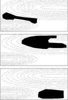
Topography comes first. A settlement requires a plan for its relationship with the existing topography. If the relief is varied, there are a number of traditional alternatives [Fig 11.8]: 11.8 Three traditional arrangements for the relationship between landform and builtform: a valley town, a hill town and a plains town -build in the valleys and leave the hills as open space -build on the hills and the leave the valleys as open space -build on the plain, avoiding hills and valleys If the settlement is beside a large body of water, there are other alternatives: -place buildings along the water's edge (eg Venice)front -locate public open space on the waterfront (eg Chicago) -build a corniche on the waterfront (eg Cairo) -a blend of the above policies (eg London and Paris) When decisions have been taken about the relationship between builtform and landform, one can think about the disposition of other land uses. It is particularly important to find good topographic positions for a town centre and town park. A study of the postï¾war British new towns will show that where town centres have been given significant topographic positions, such as the valleys at Hemel Hempstead and Livingston, or the hilltops at Harlow, Redditch, and Cumbernauld, it is much easier to appreciate the form of the town and to find one's way about. Where the town centres do not have topographically significant sites, as at Bracknell, Crawley, Cramlington, and Newton Aycliffe, the visitor is often confused. On flat sites, a skyline and landmark policy can aid orientation.