Rural land needs to be mapped in many ways.
Departments of Agriculture, as distinct from farmers, have tended to focus on the single objective of agricultural production. So they only collect data related to this objective. In America, land capability maps are published by the Soil Conservation Service. Class I soils have few limitations for agriculture and Class VII soils have severe limitations. One might use this classification to reach the conclusion that Class I soils should be farmed and Class VII soils should be available for non-agricultural uses, including urbanisation. This is a crudely simplistic approach to land development. Land with high agricultural value will often have low scenic, recreational, wild-life value and urbanisation value.
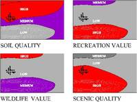
Agricultural land should be mapped in different ways [Fig 7.20], some of which are listed below:
7.20 The countryside can be mapped in different ways
Arable value: high, medium, low
Grazing value: high, medium, low
Tree crop value: high, medium, low
Horticultural value: high, medium, low
Accessibility: high, medium, low
Nature conservation value: high, medium, low
Skiing value: high, medium, low
Hunting value: high, medium, low
Watersports value: high, medium, low
Picnic value: high, medium, low
Hiking value: high, medium, low
Scenic value: high, medium, low
Historic value: high, medium, low
Aquifer recharge value: high, medium, low
Flood storage value: high, medium, low
The maps can be used to discover what public goods are available, and to make plans. If an area of highly productive agricultural land is near a large town, it is unlikely that food production will be the most beneficial land use. Money should also be spent to protect and increase the supply of non-agricultural public goods.