- England
- Scotland
- France
- Holland
- Germany
- Italy
- Spain
- Portugal
- USA
- China
- Japan
- India
- Iran
- Advice
- Gardens
- England
- Scotland
- France
- Holland
- Germany
- Italy
- Spain
- Portugal
- USA
- China
- Japan
- India
- Iran
- Advice
- Garden Tours
Book: Landscape Planning and Environmental Impact Design: from EIA to EID
Chapter: Chapter 1 The future of town and country planning
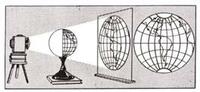
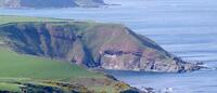
Three-dimensional design, and the natural tendency for places to evolve and change, have been comparatively neglected by planners. Map-making and planning have ebbed and flowed together. They declined with the Roman empire and resumed their advance with the renaissance. Surveying and cartography have a profound influence on geography and planning. Our verb 'to plan' derives from the noun 'plan', meaning a two dimensional projection on a plane surface [Fig 1.5]. A 'plan' is a projection of a 3-dimensional object onto a plane surface The word geography comes from geo, meaning 'the earth' and graphein, meaning 'to write'. Geography is the science which describes the Earth's surface and explains how it acquired its present character. Before the age of Darwin, Christendom believed the Earth to have been created in six days. Darwin's theory of evolution changed this belief. When geologists examined the evidence, it was found that the Earth had evolved by infinite degrees on a geological timescale. Ruskin, when he sat to contemplate God and Nature, kept hearing 'those terrible hammers' chipping away at the bedrock of his faith. Geikie, a geologist, adopted and adapted the word 'landscape' to impart an evolutionary worldview [Fig 1.6]. The Oxford English Dictionary cites one of his books, published in 1886, as the first occurrence of 'landscape' in its predominant modern sense: 'a tract of land with its distinguishing characteristics and features, esp. considered as a product of shaping processes and agents (usually natural)' (Oxford English Dictionary 1976). The descriptive use of the word landscape became predominant. Before Giekie, the word 'landscape' was used in a sense which derived from the Neoplatonic theory of art, to mean 'an ideal place'. It was an evaluative word, eminently suited to characterising a goal of the planning and design process. Landscape painters sought to represent an ideal world on canvas [Fig 1.7]. Landscape designers sought to make landscapes of country estates [Fig 1.8]. However, the evaluative connotations of 'landscape' were never entirely discarded: if we speak of 'a wretched landscape', the phrase has a deliberate internal tension. Caption: Giekie's gave the word 'landscape' (formerly an artist's term) a new meaning by using it to describe the end product of topographical evolution. The photograph shows 'Hutton's unconformity' (Siccar Point) which, by the conjunction of red sandstone and greywacke, was used to prove that landscapes had evolved over an endless period of time - and were not made in the Biblical 7 days. Once the concept of landscape evolution had been grasped, it was natural for planners to look beyond city boundaries. They considered a wide range of geographical phenomena and extended their professional interests beyond the types of plans produced by cartographers, surveyors, architects and engineers. Patrick Geddes, inspired by French geography, was the most influential agent of this change. He had trained as a biologist with Darwin's collaborator, Thomas Huxley. Geddes was also the first British citizen to use 'landscape architect' as a professional title. He became a founder member of Britain's Town Planning Institute and his Survey-Analysis-Plan methodology formalised the link between modern geography and modern planning [Fig 1.9]. The American Institute of Planning was an offshoot of the American Society of Landscape Architects.